
 地圖及定位
地圖及定位
# PinToo之地圖及定位
# 1. 說明
該功能可實現高德地圖的顯示以及定位資訊的輸出。
使用智能手機上的PinToo應用程式,實現顯示高德地圖的功能,包括顯示普通地圖與衛星地圖,設定地點資訊等功能;實現定位功能,提供定位獲取的周邊相關資訊。包括經緯度資訊,所在地區的地址資訊等。在使用以下功能之前,請先確認是否有給予PinToo相應的許可權。
# 2. 設計明細
開啟PinToo設計器,分別加入下插圖之控制元件。或者點選左上角的[打開模板Lib檔案],選擇模板檔案來打開對應模板。
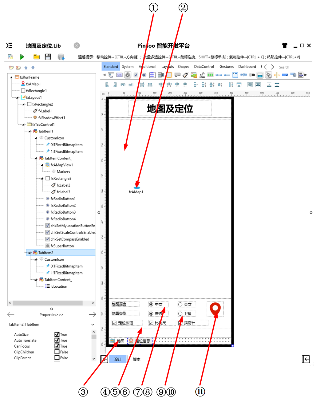
①:TfxAMapView元件,控制元件名稱為fxAMapView1。
②:TfxAMap元件,控制元件名稱為fxMap1。
③:TfxTabControl元件,控制元件名稱為fxTabControl1。
④:TfxCheckBox元件,控制元件名稱為chkSetMyLocationButtonEnabled。
⑤:TfxCheckBox元件,控制元件名稱為chkSetScaleControlsEnabled。
⑥:TfxCheckBox元件,控制元件名稱為chkSetCompassEnabled。
⑦:TfxRadioButton元件,控制元件名稱為fxRadioButton1。
⑧:TfxRadioButton元件,控制元件名稱為fxRadioButton2。
⑨:TfxRadioButton元件,控制元件名稱為fxRadioButton3。
⑩:TfxRadioButton元件,控制元件名稱為fxRadioButton4。
(11):TfxSuperButton元件,控制元件名稱為fxSuperButton1。
fxRunFrame屬性設定
Height:設定頁面高度=800。Width:設定頁面寬度=400。
①fxAMapView1屬性設定
Height:設定控制元件高度=585。Width:設定控制元件寬度=400。
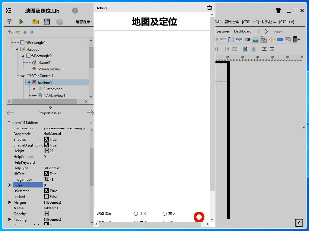
③fxTabControl1屬性設定
Align:設定控制元件對齊方式=Client。佔用客戶區,標題部分對齊方式為Top。 雙擊fxTabControl1顯示如下圖所示的對話方塊,點選Add Item按鈕可新增Tab項。分別修改對應的Tab專案中的屬性。 新建完成後包含兩個
TabItem,分別對應為TabItem1與TabItem2。TabItem1放置與地圖顯示相關的控制元件,TabItem2中放置與定位資訊顯示相關的控制元件。
TabItem1屬性設定
CustomIcon:設定圖示,雙擊該屬性或者點選右側的[...]打開自定義圖表編輯器,點選左上角的[打開]打開資源管理器選擇所需的圖示檔案,點選[確認]將圖示載入至編輯框中。可對圖示的順序進行調整,預設顯示的是第一個圖示。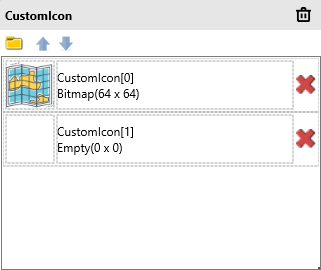
Text:設定頁面標籤顯示的文字內容=地圖。
TabItem2屬性設定
CustomIcon:設定圖示,雙擊該屬性或者點選右側的[...]打開自定義圖表編輯器,點選左上角的[打開]打開資源管理器選擇所需的圖示檔案,點選[確認]將圖示載入至編輯框中。可對圖示的順序進行調整,預設顯示的是第一個圖示。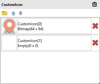
Text:設定頁面標籤顯示的文字內容=定位資訊。
④chkSetMyLocationButtonEnabled屬性設定
Name:設定控制元件名稱=chkSetMyLocationButtonEnabled。Text:設定確認框的文字名稱=定位按鈕。
⑤chkSetScaleControlsEnabled屬性設定
Name:設定控制元件名稱=chkSetScaleControlsEnabled。Text:設定確認框的文字名稱=比例尺。
⑥chkSetCompassEnabled屬性設定
Name:設定控制元件名稱=chkSetCompassEnabled。Text:設定確認框的文字名稱=指南針。
⑦fxRadioButton1屬性設定
GroupName:設定單選按鈕所在的分組名稱=Language。Text:設定單選按鈕顯示的文字內容=中文。
⑧fxRadioButton2屬性設定
GroupName:設定單選按鈕所在的分組名稱=Language。Text:設定單選按鈕顯示的文字內容=英文。
⑨fxRadioButton3屬性設定
GroupName:設定單選按鈕所在的分組名稱=Type。Text:設定單選按鈕顯示的文字內容=普通。
⑩fxRadioButton4屬性設定
GroupName:設定單選按鈕所在的分組名稱=Type。Text:設定單選按鈕顯示的文字內容=衛星。
(11)fxSuperButton1屬性設定
Height:設定控制元件高度=50。Width:設定控制元件寬度=50。ButtonType:設定按鈕型別,設定為TfxSvgButton。ButtonType.SvgData:設定SVG數據,其數據內容如下。
<path d="M27.4999485015869,3 C17.6554374694824,3 9.67519760131836,10.3865594863892 9.67519760131836,19.4994983673096 C9.67519760131836,33.249095916748 24.5290336608887,47 27.4999485015869,47 C30.4710178375244,47 45.3248023986816,33.249095916748 45.3248023986816,19.4994983673096 C45.3248023986816,10.3865585327148 37.3445129394531,3 27.4999485015869,3 Z M27.4999485015869,29.3999309539795 C22.5777187347412,29.3999309539795 18.5869960784912,25.4601078033447 18.5869960784912,20.5999698638916 C18.5869960784912,15.7398309707642 22.5777187347412,11.800009727478 27.4999485015869,11.800009727478 C32.4222793579102,11.800009727478 36.411750793457,15.7398309707642 36.411750793457,20.5999698638916 C36.411750793457,25.4601078033447 32.4222259521484,29.3999309539795 27.4999485015869,29.3999309539795 Z" p-id="9777" fill="#FFD81E06" stroke="Null"></path>1
# 3. 程式設計
點選程式設計界面右下角的按鈕,切換至單元選擇界面,勾選需要使用的單元。該程式需要引用AMap,AMapNavi,AMapView單元。
# 3.1. 程式初始設定
設定預設函式SetViewItem,用於快速向TfxListView元件對應的lvLocation中插入內容。
procedure SetViewItem(AText: String; ADetail: String);
begin
  with lvLocation.Items.Add do
  begin
    Text := AText;
    Detail := ADetail;
  end;
end;
2
3
4
5
6
7
8
在程式啟動時顯示地圖。並顯示指南針、比例尺、定位按鈕等資訊。
Begin
  fxAMapView1.SetMyLocationEnabled(true);
  // 顯示指南針
  fxAMapView1.SetCompassEnabled(true);
  // 顯示比例尺
  fxAMapView1.SetScaleControlsEnabled(true);
  // 顯示定位按鈕
  fxAMapView1.SetMyLocationButtonEnabled(true);
  fxAMapView1.SetMyLocationEnabled(true); // 顯示我的位置
  fxAMapView1.SetMyLocationType(LOCATION_TYPE_FOLLOW);
  fxAMapView1.ShowMyLocationSingle(CCAMap_MarkerType_HUE_RED);
End.
2
3
4
5
6
7
8
9
10
11
12
# 3.2. 事件設定
- TabItem1-OnClick事件
當點選頁面切換至地圖模式時顯示高德地圖的內容。
Procedure TabItem1OnClick(Sender: TObject);
//高德地圖顯示
Begin
  fxAMapView1.Visible := True;
End;
2
3
4
5
- TabItem2-OnClick事件
當點選頁面切換至定位資訊模式時,高德地圖關閉顯示並開啟定位服務。
Procedure TabItem2OnClick(Sender: TObject);
//高德地圖顯示關閉
Begin
  fxAMapView1.Visible := False;
  lvLocation.ItemAppearanceObjects.ItemEditObjects.Detail.Height := 24;
  fxAMap1.StartLocation;
End;
2
3
4
5
6
7
- ②fxAMap1-OnLocationChangedCallbackEvent屬性設定
當控制元件獲取到定位資訊時,更新定位資訊並在列表中顯示。
Procedure fxAMap1OnLocationChangedCallbackEvent(Sender: TObject; ErrorCode: Integer; ErrorInfo: string; LocationDetail: string; LocationType: Integer; Longitude: Double; Latitude: Double; Altitude: Double; Accuracy: Single; Provider: string; Speed: Single; Bearing: Single; Satellites: Integer; Country: string; Province: string; City: string; CityCode: string; District: string; AdCode: string; Address: string; PoiName: string; LocationTime: string; isWifiAble: Boolean; isWifiAbleString: string; GPSStatus: Integer; GPSStatusString: string);
Begin
    lvLocation.BeginUpdate; //修改ListView時要啟用Update
  try
    lvLocation.Items.Clear; //更新前清空ListView中的內容
    SetViewItem('提供者:'+ Provider,'');
    SetViewItem('經度:'+ FloatToStr(Longitude),'');
    SetViewItem('緯度:'+ FloatToStr(Latitude),'');
    SetViewItem('海拔:'+ FloatToStr(Altitude) + '米','');
    SetViewItem('精度:'+ FloatToStr(Accuracy) + '米','');
    SetViewItem('角度:'+FloatToStr(Bearing),'');
    SetViewItem('速度:'+ FloatToStr(Speed) + '米 / 秒','');
    SetViewItem('國家:'+  Country,'');
    SetViewItem('省:'+  Province,'');
    SetViewItem('市:'+ City,'');
    SetViewItem('城市編碼:'+  CityCode,'');
    SetViewItem('區:'+  District,'');
    SetViewItem('區域碼:'+  AdCode,'');
    SetViewItem('地址:'+  Address,'');
    SetViewItem('興趣點:'+  PoiName,'');
    SetViewItem('定位時間:'+  LocationTime,'');
    SetViewItem('WIFI開關:', isWifiAbleString);
    SetViewItem('GPS狀態:', GPSStatusString);
  finally
    lvLocation.EndUpdate(); //修改完成後,完成Update
  end;
End;
2
3
4
5
6
7
8
9
10
11
12
13
14
15
16
17
18
19
20
21
22
23
24
25
26
27
- ⑦fxRadioButton1-OnClick事件
當點選語言為中文單選按鈕時,設定地圖語言為中文。
Procedure fxRadioButton1OnClick(Sender: TObject);
//設定地圖語言為中文
Begin
  fxAMapView1.SetMapLanguage('zh_cn');
End;
2
3
4
5
- ⑧fxRadioButton2-OnClick事件
當點選語言為英文按鈕時,設定地圖語言為英文。
Procedure fxRadioButton2OnClick(Sender: TObject);
//設定地圖語言為英文
Begin
  fxAMapView1.SetMapLanguage('en');
End;
2
3
4
5
- ⑨fxRadioButton3-OnClick事件
當點選地圖型別為普通按鈕時,設定地圖型別為普通地圖。
Procedure fxRadioButton3OnClick(Sender: TObject);
//設定為普通地圖
Begin
  fxAMapView1.SetMapType(MAP_TYPE_NORMAL);
End;
2
3
4
5
- ⑩fxRadioButton4-OnClick事件
當點選地圖型別為衛星按鈕時,設定地圖型別為衛星地圖。
Procedure fxRadioButton4OnClick(Sender: TObject);
//設定為衛星地圖
Begin
  fxAMapView1.SetMapType(MAP_TYPE_SATELLITE);
End;
2
3
4
5
- (11)fxSuperButton1-OnClick事件
當點選定位按鈕時,地圖的相機將會移動至指定的經緯度區間內。
Procedure fxSuperButton1OnClick(Sender: TObject);
//移動相機至指定經緯度
Begin
  fxAMapView1.MoveCamera(120.1,30.3,1,1,1); //前兩個數據為經緯度。
  fxAMapView1.Zoom(18);
End;
2
3
4
5
6
- ④chkSetMyLocationButtonEnabled-OnChange事件
當定位單選框選項發生變化時,根據其選中的情況來確定是否開啟定位按鈕的顯示。
Procedure chkSetMyLocationButtonEnabledOnChange(Sender: TObject);
//選擇「定位按鈕」,地圖上顯示定位按鈕(按鈕位於地圖的右上角,點選可移動至當前定位點的地圖區域)
Begin
  fxAMapView1.SetMyLocationButtonEnabled(chkSetMyLocationButtonEnabled.IsChecked);
End;
2
3
4
5
- ⑤chkSetScaleControlsEnabled-OnChange事件
當比例尺單選框選項發生變化時,根據其選中的情況來確定是否開啟比例尺的顯示。
Procedure chkSetScaleControlsEnabledOnChange(Sender: TObject);
//選擇「比例尺」,地圖上顯示比例尺(比例尺一般位於地圖左下角)
Begin
  fxAMapView1.SetScaleControlsEnabled(chksetScaleControlsEnabled.IsChecked);
End;
2
3
4
5
- ⑥chkSetCompassEnabled-OnChange事件
當指南針單選框選項發生變化時,根據其選中的情況來確定是否開啟指南針的顯示。
Procedure chkSetCompassEnabledOnChange(Sender: TObject);
//選擇「指南針」,地圖上顯示指南針(指南針一般位於地圖的左上角)
Begin
  fxAMapView1.SetCompassEnabled(chksetCompassEnabled.IsChecked);
End;
2
3
4
5
- ①fxAMapView1-OnLocationChangedCallbackEvent事件
當定位資訊發生變化時,在地圖上進行定位的標註。
Procedure fxAMapView1OnLocationChangedCallbackEvent(Sender: TObject; ErrorCode: Integer; ErrorInfo: string; LocationDetail: string; LocationType: Integer; Longitude: Double; Latitude: Double; Altitude: Double; Accuracy: Single; Provider: string; Speed: Single; Bearing: Single; Satellites: Integer; Country: string; Province: string; City: string; CityCode: string; District: string; AdCode: string; Address: string; PoiName: string; LocationTime: string; isWifiAble: Boolean; isWifiAbleString: string; GPSStatus: Integer; GPSStatusString: string);
//當位置資訊發生變化時實時顯示
Begin
  if ErrorCode = 0 then
  begin
      //fxLabel1.Text := Address;
      fxAMapView1.Zoom(18);
      fxAMapView1.AddMarker3(Longitude + 0.00026, Latitude + 0.00016,'我是您的鄰居', '遠親不如緊鄰!', true, 0.0, true);
  end;
End;
2
3
4
5
6
7
8
9
10
# 4. 運行結果
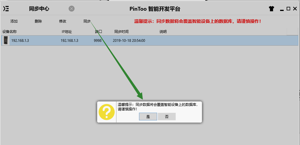
使用滑鼠在 PinToo 功能表,點選[儲存至資料庫]按鈕,將其儲存至資料庫,點選[除錯運行]確認能夠正常打開。
通過同步中心,將程式上傳至手機PinToo運行;同步時,請確保手機已經運行PinToo,並且已經登陸。
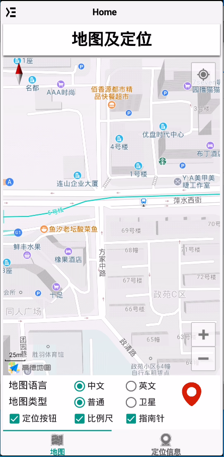
程式啟動后預設顯示地圖,可點選地圖語言,地圖型別中的單選按鈕,以及定位按鈕,比例尺,指南針等選框來檢視地圖顯示的效果。右側的定位按鈕點選可移動相機視角至指定的經緯度。
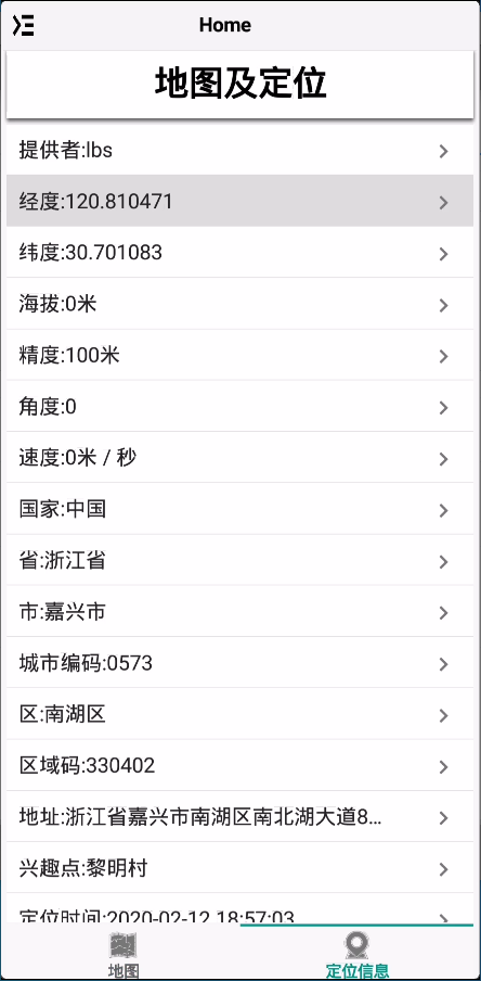
切換至定位資訊欄,其中羅列了定位獲取到的數據資訊。可使用其中的經緯度資訊作為定位數據的採集。